Middle Sugarloaf and North Sugarloaf

| Date: | 5-19-2024 |
| Location: | Bethlehem, NH |
| Distance: | 3.91 mi |
| Elevation Gain: | 962′ |
| Total Time: | 3 hr 15 min |
| Parking: | 8+ cars |
Sunday morning what to do? I want to drive north but don’t want to deal with the traffic coming home. Maybe if I leave a little later so I end up coming home later in the afternoon there will be less traffic. Nope.


I arrived at the Sugarloaf parking area on Zealand Road around 11am. There were a lot of cars along the road and the lot looked full. But as I got closer, I saw a spot in the lot I could squeeze into.
I grabbed my stuff and headed to the trail head on the other side of the bridge. The trail follows a brook for a short ways and this starts to angle up with an easy grade.

Soon the trail starts to climb a bit more. This area is full of giant boulders and granite slabs. Some of them are almost like a cave. The trail goes right through them.
I continued and the trail grade is now moderate. Lots of different trees, ferns and moss along the trail. Mushrooms were everywhere.

I kept climbing and noticed I had not seen many people. I thought this was strange since there were so many cars at the lot. The trail steepened and it looks like there was a lot of stone steps now. As I climbed I heard some people coming down.
From here the steepness continued until I hit the ridge line. I decided to do Middle Sugarloaf first. I like this .4 section of the trail. It goes along mossy ledges and then climbs through some rocky forest.

As I approached the summit it gets a bit bouldery right before I got to the wooden steps/ladder. From here it is a short distance to the summit ledges.
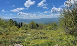
The views are nice but it was a bit cloudy and hazy in the mountains. I think there are some fires up in Canada that are contributing to the haze.

After a quick walk around the summit and a few pictures I headed back down the trail and over to North Sugarloaf. Going down was much quick then going up. Temps were nice but it was a bit humid out.
I made to the junction sign where I came up and headed to north. It is only .3 mi to the summit and less elevation. I first arrived just under the cliffs and then the trail dips down a bit.


The trail goes around the mountain a bit and I soon reached a mineral area along the trail. Lots of quartz around. There are also signs that say not to disturb the rocks.
I got the summit shortly after and explored the ledges that looked back to Middle Sugarloaf. Then I saw a short trail on my GPS and followed that for a bit before heading back down to the trail junction.

Once back at the junction it took about 45 mins to get back to my vehicle. Toward the bottom of the trail just before the stream I could see some small rain drops falling fro the sky. I arrived back at the car just in time, the rain started pouring down. This was a nice solo hike for me. It was just under a 1000 feet in elevation and a bit over four miles.


