Mt. Thumb and Mt. Skatutakee in Hancock, New Hampshire

| Date: | 04-29-2023 |
| Location: | Hancock, NH |
| Distance: | 5.1 mi |
| Elevation Gain: | 828′ |
| Total Time: | 4 hr 8 min |
| Parking: | 10+ cars |
| Difficultly Rating: | Easy/Moderate |
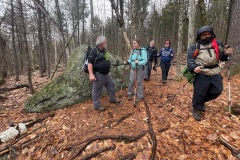
Met up with a group of friends for a hike up Mt. Thumb and Mt. Skatutakee. Weather was cloudy with forecast for rain but that didn’t stop us from spending a little time outdoors.
Parking is limited at the trail head, so we met up in Hillsboro, NH and carpooled over to the trail head at the Harris Center in Hancock, NH.

Once we were all parked, we headed up the trail. I’ve been wanting to do this loop trail over Mt. Thumb and Mt. Skatutakee for a while. There are several cool wood carvings along the first .5 miles of trail.

After crossing a brook and small waterfall cascade, we reached the junction to the loop. We took the Thumbs Down trail up. About a mile in we came to a small pond where we could see Mt. Thumb above.

We continued around the pond and up the slop of our first mountain. The trail was rooty and rocky much of the way. The trail climbed steadily up to a spur path where we regrouped before taking the path up to the summit of Mt. Thumb.

The Thumbs Up spur path starts out steep but not for very long. We climbed up to the summit and then and then over to a little stone circle and a viewpoint. We all took a break and a few photos of the cloudy horizon.

It started to rain a little, so we all packed up and headed back down to the main path below. Once we climbed back down the steep section we continued toward Mt. Skatutakee.

The climb to Mt. Skatutakee starts gradual but has a few steeper sections along it. Just before the summit there is a junction with another path that takes you away from the loop. So be sure you are on the right path.

After about 20 minutes we packed up and headed down the mountain on the Harriskat trail. There are a few steep ad slippery sections toward the top when wet. After that the trail is gradual with some rooty sections.

A few yards further we came to a big opening with great views of Mt. Monadnock and the town of Handcock below. Again, we took another break and a bunch of photos.

Soon we were back at the trail loop junction and started back on the wood carvings trail back to the lot. Overall, we did about 5 miles and 828 feet of elevation. This was a perfect hike to start getting in to hiking shape again.


