Five Finger Point Natural Area

| Date: | 5-3-2025 |
| Location: | Holderness, NH |
| Distance: | 3.43 mi |
| Elevation Gain: | 308′ |
| Total Time: | 2 hr 8 min |
| Parking: | 6-7 cars |
With another weekend of forecasted rain, I decided to salvage a few sunny hours in the morning with a short hike to The Five Finger Point Natural Area. The weather was bright and sunny on the drive up but cloudy once I got to the trail head.

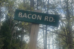
I also planned to hike East and West Rattlesnake form this trail head if the weather held out. When I got to the trail head there was one other car there. I love the fact that this lot is on Bacon Road. The lot could hold about 6-7 cars if people park politely.

The trail is across the street from the lot. There is a kiosk with a map of this area. I started out on the trail. It is pretty level for a little way. There are not any tough or challenging inclines on this trail.
It first goes by a shed and an old barn or workshop. Shortly after that I got to the junction of East and West Rattlesnake trail. I kept on the Five Finger Trail. The trail gradually inclines for a while and dips a little a few times before the last dip down to the lake.

Once I got the Five Finger Point Natural Area, there was a sign to start the loop trail. I decided to go counterclockwise. There are a few small lookouts along this trail and I was wishing I brought my fishing pole.

When I got to the first point there was a sign for boaters for Five Finger Point Natural Area. It was a nice clearing with great views of the lake. There was also another cool sign for the natural area, and it noted this was day use only. What made it cool was all the weathering of the sign. The letters were raised because the wood was weathered.

The sun was trying to break through the clouds. I took a few pics before moving on. As I walked around the island there were a lot of really neat rock formations.
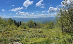
As I approached the east side of the trail, there was a small heard path that lead to another great lookout. I think I liked this lookout best because you could see half of the squam range.

A short while later I was back at the beginning of the loop. From here I started back the way I came. There were a few more people on the trail coming up from the lot. Shortly after that I started to feel a few rain drops and the clouds were getting darker and I decided I would not be going up the Rattlesnake Mountains.

When I got the kiosk the rain really started to come down hard. I felt bad for some of the other hikers. This was a fun little trail. It is worth exploring if you have some time and are around Squam Lake.


